 Moonlight bouncing off a sun-reddened arm that’s bouncing along the chiefdom back roads at dusk, holding a GPS unit as far out from the back of the speeding motorbike as possible to catch the final satellite communications before heading home after a long day on dusty roads collecting school way point data for UNDP maps. Until today I’ve been able to be safely out in the sun all day without worry (I’m sure the sun is less intense here). Tonight I’m feeling both slightly burnt and quite hungry. Strangers arrived in town and so my rice was reallocated before I returned. I’m often told, though, that it really isn’t necessary to eat every day and very easy to put your mind to other thoughts when distracted by hunger. And I’m not to worry as Kouame, whose rice was also reallocated and who consequently is also hungry, discovered he had a pineapple which he’ll put aside to provide a good breakfast for our strangers. This (giving your last food to guests and then going hungry yourself) is the norm here, and I suppose that I’m happy to be considered as a more of a host than guest.
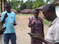
 This GPS chiefdom mapping project has been fascinating and I expect will continue to be part of our lives for years to come. For now we are charting the locations of roads, schools and health centres on a base map provided by the UNDP. Our mapping team is made up of seven youth leaders and volunteer teachers who are giving up their time to travel to the remote corners of the chiefdom in three teams on foot, bicycle, and motorbike (that’s me) with GPS in hand and toothbrush in back pocket, as in walk-in areas especially, it’s not possible to go and come in one day. So far we’ve lost only one of the team, as bicycle-riding Mabinty veered to avoid an on-coming motorbike and did some damage to her hands when she landed in the bush. We’re hoping she’ll recover soon enough to join us all for some celebratory palm wine, provided by the first team to complete data collection. As I travel through the chiefdom, stopping in tiny villages or clusters of compounds, passing over makeshift log-bridges (closing eyes tight and hoping the bike doesn’t slip), traversing fresh groundnut or cassava heaps, wafting through the pungent aroma of sweet flowers that seems to hang perpetually over streams, glancing past the water lilies that are out in full-force, feeling the cool relief of shade when passing through the remnants of old forest, and stopping to chat with the few remaining pleased teachers (it’s school holiday time), curious elders, and wondering or terrified (depending on age) children, I can imagine returning to the roads and paths many times with the GPS. As mentioned before, lack of information about the chiefdom and rest of the world and inability to communicate easily with the next village or beyond has played a huge role in problems faced here (highest maternal and child mortality rate in the world, etc.). Being able to collect and share information will, we all hope, contribute to positively addressing some of these problems (knowing and being able to talk about the many areas where vehicles can’t travel or people can’t easily reach a clinic or school should help us solve these problems). So I suppose the burnt shoulders and empty belly will fade in memory soon enough and I hope the positive recollections and results of this experiment will last long beyond the life of the second draft map we’re creating of the Paki Masabong chiefdom.
At the end of today, our second day of mapping, we rolled back into Mapaki with fowl in hand (a gift from John S. Bangura), motorbike repaired (it seems to disintegrate a little faster on each patrol), pineapple strapped to the side of the bike (gift from Malai), and all waypoints charted. I found my rice pan filled with double rations and there were both fish heads and chicken in my groundnut plasass. Life is good.
Other news. I was delighted to spend two days this week with Maggie, Shan, and Anna from the University of Bradford Peace and Conflict studies program and hope that this will lead to a long-term relationship between the chiefdom and university (they can follow our developments through Google Earth after we finish uploading maps and photos). These very thoughtful and reflective young women give me great hope for the potential of formal learning institutions to foster a sense of responsibility and commitment and a desire to work well collectively for a just and peaceful world. We all look forward to crossing paths with the three again.
And the final garden report. This week the tiny tomatoes ripened, which have been the only variety that survived. All other beds have now been replanted in local okra or left fallow (except for the lone cabbage family and basil that has struggled along under netting and the parsley that withstood the grasshoppers). Meanwhile, the farmers around here have pushed forward with brushing and there are many areas of bush that have been laboriously hand cleared of trees by cutlass and are ready for burning. The amount of manual labour that goes into producing a basketful of rice or cassava is frightening and people still talk longingly of the pre-war days when they had access to the occasional tractor, work-oxen and fertilizer. It’s been over a year now since I first arrived in Sierra Leone and I think I’m finally starting to understand the annual cycle of agricultural work, just in time to head back to Canada’s very short growing season.
Photo: Usifu, Mabinty, and AKT prepare with the UNDP GPS units
 Moonlight bouncing off a sun-reddened arm that’s bouncing along the chiefdom back roads at dusk, holding a